
GEOGRAPHY (VI)-LESSON-7
OUR COUNTRY -INDIA
(LESSON NOTES)
____________________________________________________________
v
INTRODUCTION: -
Ø India is the vast country.
It has so much diversities not only in cultural terms but also in physical. In
this lesson we will learn about these physical features.
v
INDIA-SIZE
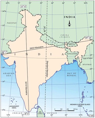
Ø India is a vast country. It has an area of about
3.28 million sq. km.
Ø It is the 7th largest country of the
world in size.
Ø The North-South extent from
Kashmir to Kanyakumari is about 3,214 km. Thus, the west extent from Arunachal
Pradesh to Kuchchh is about 2933 km.
Ø According to the census of
2011, India’s population is 121 Crores and have the second place after China.
Ø In India there is a great variety in the landforms, climate, vegetation, wildlife as well as in the language and culture.
v INDIA LOCATION:
Ø India in the North is bounded by the Himalayas, the
Arabian Sea in the West, the Bay of Bengal in the East and the Indian Ocean in
the South.
Ø From South to North. India extends between 8°4′ N
and 37°6′ N latitudes.
Ø From West to East, India extends between 68°7′ E
and 97°25′ E longitudes.
Ø The Tropic of Cancer (23°30′ N) passes almost
halfway through the country.
Ø The local time changes by four minutes for every
one degree of longitude.
Ø The local time of longitude of 82°30′ E has been
taken as the Indian Standard Time.
v INDIA’S NEIGHBOURS
Ø
There are seven countries that share land boundaries with India.
Ø
The seven countries are: -
§
Afghanistan, Pakistan- In north west
§
China, Nepal, Bhutan in North.
§
Myanmar and Bangladesh in East.
§
In South Island neighbours are Sri Lanka and the Maldives. Sri Lanka is
separated from India by the Palk Strait.
v
INDIA’S POLITICAL AND ADMINISTRATIVE DIVISIONS
Ø
India is divided into 28 states and 8 union territories.
Ø
Delhi is the national capital.
Ø
Rajasthan is the largest state and Goa is the smallest state in terms of
area.
Ø
In term of population largest sate is Uttar Pradesh and Smallest state
is Sikkim.
v
PHYSICAL DIVISIONS: -
Ø India is marked by a diversity of physical features such as mountains, plateaus, plains, coasts and islands. According to the physical features India is divided into six divisions.

1. THE NORTHERN HIMALAYA: -
§
The Himalaya lies toward the North of country from Ladakh Jammu Kashmir
to Arunachal Pradesh. It means Abode of Snow.
§
It is divided into three main parallel ranges: -
·
The Great Himalaya or Himadri: - It is always covered with snow. World highest mountain
Peaks are in this range as: -
¨
Mount Everest (Nepal)-World Heighest-8848 feet
¨
K2 (POK)- India’s Highest but in Pak Authorised Kashmir
¨
Kanchenjunga (Sikkim)- India Highest
·
Middle Himalaya or Himachal: - It lies to the south of Himadri. Many popular
hill stations are situated here as:-
¨
Kullu Manali-Uttarakhand
¨
Dalhousie-HP
¨
Sri Nagar- Jammu & Kashmir
¨
Kaauli-
¨
Jalpaiguddi- West Bengal
·
Shiwalik: - The Shiwalik is the southernmost range.
2. THE NORTHERN INDIAN PLAINS:
-
§
It lies to the South of the Himalayas.
§
They are generally level and flat. These are formed by the alluvial
deposits laid down by the rivers–the Indus, the Ganga, the Brahmaputra and
their tributaries.
§
These river plains provide fertile land for cultivation.
§
That is the reason for high concentration of population in these plains.
3. THE GREAT INDIAN DESERT: -
§
It lies toward the western part of India. It is known as Thar Desert.
§
It is a dry, hot and sandy stretch of land.
§
It has very little vegetation such as babool, Kair, palm, dates etc.
4. THE PENINSULAR PLATEAU: -
§
It lies to the south of Northern Plain. It is triangular in shape. It is
bound by water from three sides as in South- India Ocean, in the East-Bay of
Bengal, in the West-Arabian Sea, so called as peninsular plateau.
§
In the peninsular plateau many hill ranges :-
·
Aravali hills (Rajasthan), The oldest ranges of the world,
·
The Vindhyas and the Satpuras ranges.
·
The Western Ghats or Sahyadris in the west.
·
The Eastern Ghats provide the eastern boundary
·
The rivers Narmada
§
There are many river flows in the peninsular plateau as
·
West Flowing river-Narmada and Tapi - drain into the Arabian Sea.
·
East flowing river- Mahanadi, Godavari, Krishana, Kaveri-Drain into Bay
of Bengal.
§
The plateau is rich in minerals like coal and iron-ore.
5. THE COASTAL PLAINS: -
|
WESTERN COASTAL PLAIN |
EASTERN COASTAL PLAIN |
|
It lies in between
western ghat and Arabian sea. |
It lies in between
eastern ghat and and Bay of Bengal |
|
It is narrow. |
It is much broader. |
|
Here the river does not
form the delta. |
Here the river forms the
delta. Sundarbans delta, world largest delta is form by Ganga and Brahmputra
river. |
6. THE ISLANDS: -
§ There are two groups of
islands of India.
·
Lakshadweep Islands: -
¨
These are located in the Arabian Sea.
¨
These are coral islands located off the coast of Kerala.
¨
Corals are skeletons of tiny marine animals called Polyps. When the
living polyps die, their skeletons are left. Other poplyps grow on top of the
hard skeleton which grows higher and higher, thus forming the coral islands.
¨
Its capital is Kavaratti.
· The Andaman and the Nicobar
Islands: -
¨ These lie to the South-East
of the Indian mainland in Bay of Bengal.
¨ Its capital is Port Blair.
¨
This island affected due to the Tsunami which occur on 26 December 2004.
¨
India’s south most land point is Indira Point which affected due to
Tsunami.
v IMPORTANT TERMS: -
Ø
Peninsula: A piece of land that is surrounded by water on three sides.
Ø Island: A piece of land that is surrounded by water on all sides.
Ø
Desert: A vast sandy stretch of land.
Ø
Alluvial deposits: Fine soil brought by rivers and deposited in the river basins.
Ø
Tributary: A small river or stream that contributes its water to the main
river by discharging it into the main river from either side.
Ø
Delta: An area of land formed at the mouth of the river. It is usually
triangular in shape.
Ø
Corals: These are skeletons of tiny marine animals called polyps.
Ø
Tsunami: A strong and devastating harbour wave, generated due to an
earthquake on the sea floor.
Ø
Strait: A narrow passage of water connecting two large water bodies like
seas and oceans.


No comments:
Post a Comment